Lang Co from Hai Van: reading a lagoon, a sandbar and a mountain wall in one view
The view over Lang Co holds three landscapes. How to read the Annamite spur, Lap An lagoon and the sand strip, and why weather differs on either side of Hai Van.
 Cat Ba Connect4 min read
The short answer
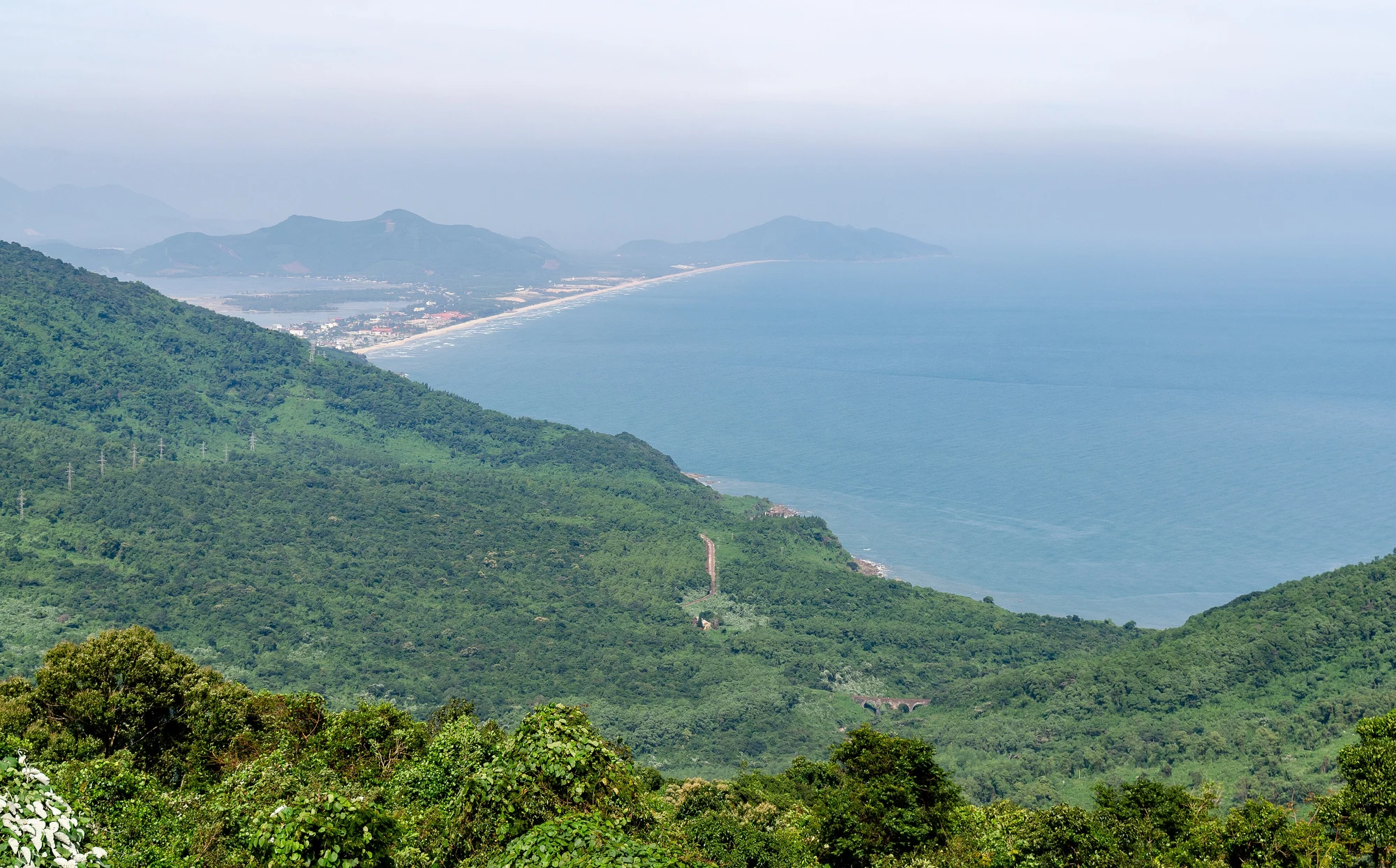
From the Hai Van road, the Lang Co view reads from back to front in three layers: a mountain wall, a sheltered brackish lagoon, and a low strip of sand between lagoon and sea. The wall is a spur of the Annamite range running into the sea, which also explains why winter weather often changes at the pass. Stop only at safe pull-offs, keep your eyes on the lagoon’s oyster stakes and tidal sandbars, and treat cloud as a normal part of a place named for sea clouds.
Stand with your back to the pass and sort the layers
Most people photograph this view without taking it apart. Try sorting it by distance. Behind you and to the sides rises the mountain. Below sits water that looks too still to be sea, and beyond it a thin line of land with the open ocean on its far side. Each layer does a different job, and the postcard works because you can see all three at once.
Wikipedia’s entry on the pass says the old road climbs to 496 metres over about 21 kilometres, and that the name means “ocean cloud pass”, because sea mist often reduces visibility. So take any fixed promise of a view with caution. A clear morning may give you the full stack; a grey one may give only the near slope and a pale sheet of water. Both are honest versions of the place.
The wall: a mountain that walks into the sea
The pass crosses a spur of the Annamite range, which runs east from the mountains to the sea and forms the Hai Van peninsula and, beyond it, Son Tra. Vietnam’s long coastal plain is cut here by rock reaching the water. That is why the railway clings to the shore through tunnels, why a road tunnel was worth building, and why this was once a frontier: Wikipedia notes the pass was a boundary between Champa and Dai Viet from 1306 until 1471.
Look for how abruptly the forested slope drops to the waterline. There is almost no plain at its foot, and that absence is the geography of a barrier. The Bach Ma range, which sources describe sheltering the lagoon, continues that high ground to the west.
Why the weather can flip
The same barrier affects the climate. Wikipedia says the pass separates northern and southern climates and shelters Da Nang from northwesterly winds, with the northern side typically wet and cold from November to March while the south stays warmer and drier. For a traveller this has a practical edge. Leaving Hue under drizzle does not mean Da Nang will be the same, and sunshine in Da Nang tells you little about the Lang Co side.
If you are choosing between the road over the top and the tunnel, check the forecast for each side, and ask your driver what they expect at the summit. A drive up for the view pays off only when visibility cooperates; the tunnel will save time when it does not.
The lagoon is a workplace
Lap An covers roughly 800 hectares of brackish water at the foot of the pass, according to Vietnam Pictorial, published by the national news agency. It is water that sits between river and sea, sheltered from waves, which is what makes it useful. The Hue tourism site says more than 100 households farm oysters here, hanging halved motorcycle tyre casings on wooden stakes so that oysters settle on them in clusters.
So those dark dots and lines on the surface are not random. They are stakes, and they mark someone’s livelihood. Vietnam Pictorial adds that long sandbars emerge at low tide and form narrow paths, with fishing villages catching the light at dawn and dusk. If you go down to the shore, stay off the sandbars unless locals show you the way, keep clear of stakes and nets, and buy oysters from people working nearby rather than helping yourself.
The strip of sand, and how to use the view
The last layer is the low land between lagoon and sea. Strips like this generally build where waves and currents move sand along a coast until it nearly closes off a bay, leaving calm water behind. A general explanation is not a site survey, so treat it as a reading habit: see which side has waves and which does not, then look for the gap where water exchanges with the sea.
Plan the stop as a decision, not a detour. Fit the pass into a transfer only if you actually want it, as the site’s Hue to Hoi An guide explains. Use signed viewpoints, keep clear of the road edge and bends, and do not ask a driver to stop on a curve. Afterwards, drop down to the lagoon if time allows.
Questions travellers ask
Is the Lang Co view worth it if the pass is cloudy?
Only partly. Cloud can hide the lagoon completely, which is common here. If the view is your main reason, keep your plan flexible or take the tunnel and visit the lagoon at water level.
Can I walk on the sandbars at Lap An Lagoon?
Sandbars can appear at low tide, but they sit among working oyster stakes and nets. Ask local people first, and leave well before the water returns.